Comanche County, Kansas
Comanche County (county code CM) is een county in de Amerikaanse staat Kansas. In 2010 woonden er 1.891 mensen. De hoofdstad is Coldwater. Coldwater is ook de grootste stad in Comanche County. Comanche County is vernoemd naar de Comanche Indianen.
Geografie
Volgens het U.S. Census Bureau heeft de county een totale oppervlakte van 790 vierkante mijl (2.000 km2 ). Daarvan is 788 vierkante mijl (2.040 km2 ) land en 1,4 vierkante mijl (3,6 km2 ) (0,2%) water.
Mensen
| Historische bevolking | |||
| Census | Pop. | %± | |
| 372 | - | ||
| 2,549 | 585.2% | ||
| 1900 | 1,619 | -36.5% | |
| 1910 | 3,281 | 102.7% | |
| 1920 | 5,302 | 61.6% | |
| 1930 | 5,238 | -1.2% | |
| 1940 | 4,412 | -15.8% | |
| 1950 | 3,888 | -11.9% | |
| 1960 | 3,271 | -15.9% | |
| 1970 | 2,702 | -17.4% | |
| 1980 | 2,554 | -5.5% | |
| 1990 | 2,313 | -9.4% | |
| 2000 | 1,967 | -15.0% | |
| 2010 | 1,891 | -3.9% | |
| Est. 2016 | 1,862 | -1.5% | |
| U.S. Decennial Census | |||

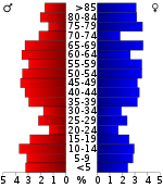
Bevolkingspiramide
Overheid
Presidentsverkiezingen
Resultaten presidentsverkiezingen
| Resultaten presidentsverkiezingen | |||
| Jaar | Derden | ||
| 2016 | 82.5% 715 | 11.8% 102 | 5.8% 50 |
| 2012 | 82.7% 767 | 15.4% 143 | 1.9% 18 |
| 2008 | 78.5% 765 | 19.9% 194 | 1.5% 15 |
| 2004 | 78.5% 770 | 20.4% 200 | 1.1% 11 |
| 2000 | 75.6% 760 | 21.0% 211 | 3.5% 35 |
| 1996 | 61.3% 691 | 26.4% 298 | 12.2% 138 |
| 1992 | 49.5% 636 | 25.3% 325 | 25.2% 324 |
| 1988 | 65.7% 738 | 33.4% 375 | 0.9% 10 |
| 1984 | 76.8% 993 | 22.0% 285 | 1.2% 15 |
| 1980 | 65.5% 877 | 29.3% 393 | 5.2% 70 |
| 1976 | 52.7% 719 | 46.2% 630 | 1.1% 15 |
| 1972 | 77.2% 1,052 | 20.6% 281 | 2.2% 30 |
| 1968 | 62.7% 906 | 31.2% 451 | 6.2% 89 |
| 1964 | 45.5% 694 | 53.7% 818 | 0.8% 12 |
| 1960 | 71.9% 1,187 | 27.9% 460 | 0.3% 5 |
| 1956 | 72.4% 1,238 | 27.0% 461 | 0.6% 11 |
| 79.0% 1,443 | 20.5% 374 | 0.6% 10 | |
| 61.9% 1,077 | 37.4% 650 | 0.8% 13 | |
| 1944 | 61.5% 1,048 | 37.7% 642 | 0.9% 15 |
| 1940 | 59.5% 1,322 | 39.6% 880 | 0.9% 20 |
| 1936 | 39.4% 932 | 60.4% 1,428 | 0.1% 3 |
| 1932 | 43.9% 945 | 54.6% 1,175 | 1.5% 32 |
| 1928 | 80.0% 1,554 | 19.8% 385 | 0.2% 4 |
| 1924 | 60.3% 1,049 | 24.8% 432 | 14.9% 260 |
| 1920 | 63.1% 1,121 | 34.4% 612 | 2.5% 45 |
| 1916 | 38.6% 732 | 50.7% 963 | 10.8% 204 |
| 1912 | 13.1% 148 | 33.3% 377 | 53.7% 609 |
| 1908 | 59.7% 392 | 37.3% 245 | 3.0% 20 |
| 1904 | 63.4% 272 | 30.1% 129 | 6.5% 28 |
| 1900 | 54.9% 249 | 42.7% 194 | 2.4% 11 |
| 44.9% 142 | 54.4% 172 | 0.6% 2 | |
| 1892 | 45.5% 259 | 54.5% 310 | |
| 1888 | 50.7% 490 | 39.7% 384 | 9.6% 93 |
Onderwijs
Geünificeerde schooldistricten
- Comanche County USD 300
Gemeenschappen
Steden
- Coldwater
- Bescherming
- Wilmore

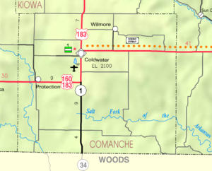
2005 KDOT Kaart van Comanche County (kaartlegende)
Meer lezen
- Standaardatlas van Comanche County, Kansas; Geo. A. Ogle & Co; 42 pagina's; 1909.
Zoek in de encyclopedie