Barton County, Kansas
Barton County (standaardafkorting: BT) is een county in de Amerikaanse staat Kansas. In 2010 woonden er 27.674 mensen. De hoofdstad is Great Bend. Great Bend is ook de grootste stad in Barton County. De county is vernoemd naar Clara Barton. Zij was verantwoordelijk voor de oprichting van het Amerikaanse Rode Kruis.
Geschiedenis
In 1867 werd Barton County opgericht. Het werd vernoemd naar Clara Barton. Het is de enige Kansas county die naar een vrouw is vernoemd.
Geografie
Barton County is getekend in de vorm van een vierkant van 48 bij 48 km. Volgens het U.S. Census Bureau heeft de county een totale oppervlakte van 901 vierkante mijl (2.330 km2 ). Daarvan is 895 vierkante mijl (2.320 km2 ) land en 5,2 vierkante mijl (13 km2 ) (0,6%) water. Het geografische centrum van Kansas ligt in Barton County.
Grote snelwegen
Bronnen: Nationale Atlas, U.S. Census Bureau
- U.S. Route 56
- U.S. Route 281
- Kansas snelweg 4
- Kansas Highway 96
- Kansas Highway 156
Mensen
| Historische bevolking | |||
| Volkstelling | Pop. | %± | |
| 10,318 | - | ||
| 13,172 | 27.7% | ||
| 1900 | 13,784 | 4.6% | |
| 1910 | 17,876 | 29.7% | |
| 1920 | 18,422 | 3.1% | |
| 1930 | 19,776 | 7.3% | |
| 1940 | 25,010 | 26.5% | |
| 1950 | 29,909 | 19.6% | |
| 1960 | 32,368 | 8.2% | |
| 1970 | 30,663 | -5.3% | |
| 1980 | 31,343 | 2.2% | |
| 1990 | 29,382 | -6.3% | |
| 2000 | 28,205 | -4.0% | |
| 2010 | 27,674 | -1.9% | |
| 2016 (schatting) | 26,775 | -3.2% | |
| Amerikaanse tienjaarlijkse volkstelling | |||
De Great Bend Micropolitan Statistical Area omvat heel Barton County.

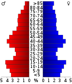
Bevolkingspiramide
Overheid
Presidentsverkiezingen
Vóór 1940 was Barton County een Democratisch swing county bij presidentsverkiezingen, en van 1912 tot 1936 een nationale bellwether. Vanaf 1940 werd het een bolwerk van de Republikeinse partij, met als enige Democratische presidentskandidaat sindsdien Lyndon B. Johnson in zijn nationale aardverschuiving van 1964.
Uitslag van de presidentsverkiezingen
| Uitslag van de presidentsverkiezingen | |||
| Jaar | Derden | ||
| 2016 | 76.3% 7,888 | 17.8% 1,839 | 5.9% 610 |
| 2012 | 76.1% 7,874 | 22.2% 2,297 | 1.6% 170 |
| 2008 | 70.6% 7,802 | 27.4% 3,027 | 2.1% 228 |
| 2004 | 74.0% 8,666 | 24.6% 2,874 | 1.4% 166 |
| 2000 | 66.7% 7,302 | 29.6% 3,238 | 3.8% 415 |
| 1996 | 64.9% 7,855 | 25.8% 3,121 | 9.3% 1,123 |
| 1992 | 37.7% 5,113 | 28.3% 3,846 | 34.0% 4,623 |
| 1988 | 59.2% 7,741 | 38.4% 5,024 | 2.4% 310 |
| 1984 | 75.6% 10,232 | 23.0% 3,111 | 1.4% 195 |
| 1980 | 66.0% 9,147 | 26.4% 3,663 | 7.5% 1,042 |
| 1976 | 55.6% 7,311 | 41.8% 5,497 | 2.5% 334 |
| 1972 | 68.9% 8,479 | 28.3% 3,481 | 2.9% 352 |
| 1968 | 54.9% 6,700 | 36.6% 4,464 | 8.6% 1,044 |
| 1964 | 39.5% 4,826 | 60.1% 7,340 | 0.5% 55 |
| 1960 | 55.6% 7,599 | 44.2% 6,036 | 0.2% 30 |
| 1956 | 66.2% 8,644 | 33.5% 4,378 | 0.3% 41 |
| 70.4% 9,380 | 28.9% 3,847 | 0.7% 92 | |
| 53.4% 6,191 | 45.8% 5,307 | 0.9% 102 | |
| 59.4% 5,547 | 40.3% 3,761 | 0.4% 37 | |
| 1940 | 54.4% 6,011 | 45.1% 4,982 | 0.5% 50 |
| 1936 | 37.1% 3,534 | 62.8% 5,978 | 0.1% 5 |
| 1932 | 40.9% 3,365 | 58.0% 4,776 | 1.2% 97 |
| 1928 | 63.9% 4,966 | 35.8% 2,777 | 0.3% 24 |
| 1924 | 56.5% 4,109 | 22.1% 1,605 | 21.5% 1,560 |
| 1920 | 68.8% 3,993 | 29.1% 1,688 | 2.2% 125 |
| 1916 | 44.5% 2,891 | 50.6% 3,292 | 4.9% 319 |
| 1912 | 17.0% 692 | 50.9% 2,069 | 32.1% 1,308 |
| 1908 | 44.8% 1,729 | 52.0% 2,004 | 3.2% 124 |
| 1904 | 58.2% 1,939 | 37.1% 1,235 | 4.7% 158 |
| 1900 | 46.5% 1,564 | 52.6% 1,772 | 0.9% 30 |
| 42.6% 1,215 | 56.6% 1,616 | 0.8% 24 | |
| 1892 | 43.1% 1,381 | 56.9% 1,823 | |
| 1888 | 49.2% 1,353 | 44.6% 1,228 | 6.2% 171 |
Onderwijs
Geünificeerde schooldistricten
De vijf schooldistricten maken deel uit van het speciale onderwijsgebied van Barton County, genaamd Barton County Special Services.
- Central Plains USD 112
- Ellinwood USD 355
- Great Bend USD 428 Archived 2011-09-07 at the Wayback Machine
- Hoisington USD 431
- Otis-Bison USD 403 (Rush County)
Hogescholen
- Barton Gemeenschap College
Gemeenschappen
Steden
- Albert
- Claflin
- Ellinwood
- Galatië
- Grote bocht
- Hoisington
- Olmitz
- Pawnee Rock
- Susank

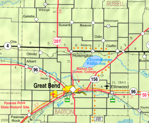
2005 KDOT Kaart van Barton County (kaartlegende)
Meer lezen
Provincie
- Atlas and Plat Book of Barton County, Kansas; Kenyon Co; 55 pagina's; 1916.
- Plat Book of Barton County, Kansas; North West Publishing Co; 47 pagina's; 1902.
Sporen
- The Story of the Marking of the Santa Fe Trail by the Daughters of the American Revolution in Kansas and the State of Kansas; Almira Cordry; Crane Co; 164 blz.; 1915.
- The National Old Trails Road To Southern California, Part 1 (LA to KC); Automobile Club Of Southern California; 64 pagina's; 1916.
Vragen en antwoorden
V: Wat is de standaardafkorting voor Barton County?
A: De standaardafkorting voor Barton County is BT.
V: Hoeveel mensen woonden er in 2010 in Barton County?
A: In 2010 woonden er 27.674 mensen in Barton County.
V: Wat is de zetel van Barton County?
A: De hoofdstad van Barton County is Great Bend.
V: Is Great Bend de grootste stad in Barton County?
A: Ja, Great Bend is de grootste stad in Barton County.
V: Wie was verantwoordelijk voor de oprichting van het Amerikaanse Rode Kruis?
A: Clara Barton was verantwoordelijk voor de oprichting van het Amerikaanse Rode Kruis.
V: Wat heeft Clara Barton te maken met Barton County?
A: Clara Barton is de naamgeefster van Barton County; het werd naar haar genoemd.
Zoek in de encyclopedie