Lijst van districten in Washington
Er zijn 39 counties in de Amerikaanse staat Washington. Washington is ontstaan uit het westelijke deel van het Washington Territory. Het werd in 1889 als 42e staat tot de Unie toegelaten. De eerste counties ontstonden in 1845 uit ongeorganiseerd…
Er zijn 39 counties in de Amerikaanse staat Washington. Washington is ontstaan uit het westelijke deel van het Washington Territory. Het werd in 1889 als 42e staat tot de Unie toegelaten. De eerste counties ontstonden in 1845 uit ongeorganiseerd gebied.
De Federal Information Processing Standard (FIPS) code, die door de overheid van de Verenigde Staten wordt gebruikt om provincies uniek te identificeren, wordt bij elk gegeven verstrekt. De links naar de FIPS-codes in de tabel verwijzen naar de "quick facts"-pagina's van de U.S. Census voor elk graafschap.
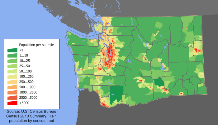
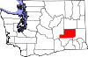
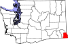
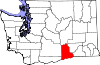
Afbeeldingengalerij
3 Afbeeldingen

Lijst
| County | FIPS-code | Provincie zetel | Gevestigd | Oorsprong | Betekenis van de naam | Bevolking | Gebied | Kaart |
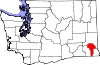
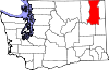
| Adams County | 001 | Ritzville | 1883 | Whitman County | John Adams (1735-1826), 2e president van de V.S. | 7004187280000000000♠18,728 | 7003192500000000000♠1,925 sq mi |
|
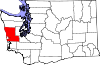
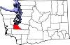
| Asotin County | 003 | Asotin | 1883 | Garfield County | De Nez Percé naam voor Eel Creek | 7004216230000000000♠21,623 | 7002636000000000000♠636 sq mi |
|
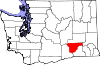
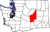
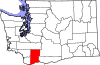
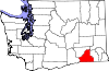
| Benton County | 005 | Prosser | 1905 | Yakima en Klickitat Counties | Thomas Hart Benton (1782-1858), senator in Missouri. | 7005175177000000000♠175,177 | 7003170300000000000♠1,703 sq mi |
|
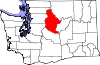
| Chelan County | 007 | Wenatchee | 1899 | Okanogan en Kittitas Counties | Een indiaans woord dat "diep water" betekent, waarschijnlijk verwijzend naar Lake Chelan | 7004724530000000000♠72,453 | 7003292200000000000♠2,922 sq mi |
|
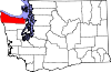
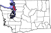
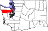
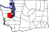
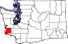
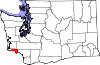
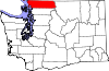
| Clallam County | 009 | Port Angeles | 1854 | Jefferson County | Een Klallam woord dat "het sterke volk" betekent | 7004714040000000000♠71,404 | 7003174500000000000♠1,745 sq mi |
|
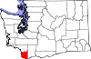
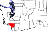
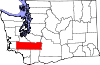
| Clark County | 011 | Vancouver | 1845 | Oorspronkelijk graafschap | William Clark (1770-1838), de co-kapitein van de Lewis en Clark Expeditie | 7005425363000000000♠425,363 | 700262800000000♠628 sq mi |
|
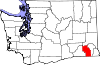
| Columbia County | 013 | Dayton | 1875 | Walla Walla County | De Columbia Rivier | 7003407800000000000♠4,078 | 700286900000000♠869 sq mi |
|
| Cowlitz County | 015 | Kelso | 1854 | Oorspronkelijk graafschap | Cowlitz, een Indiaanse stam | 7005102410000000000♠102,410 | 7003113900000000000♠1,139 sq mi |
|
| Douglas County | 017 | Waterville | 1883 | Lincoln County | Stephen A. Douglas (1813-1861), U.S. senator uit Illinois | 7004384310000000000♠38,431 | 7003182100000000000♠1,821 sq mi |
|
| Ferry County | 019 | Republiek | 1899 | Stevens County | Elisha P. Ferry (1825-1895), 1e gouverneur van de staat Washington | 7003755100000000000♠7,551 | 7003220400000000000♠2,204 sq mi |
|
| Franklin County | 021 | Pasco | 1883 | Whitman County | Benjamin Franklin (1706-1790), schrijver, redenaar, uitvinder en stichter van de V.S. | 7004781630000000000♠78,163 | 7003124200000000000♠1,242 sq mi |
|
| Garfield County | 023 | Pomeroy | 1881 | Columbia County | James A. Garfield (1831-1881), 20e president van de V.S. | 7003226600000000000♠2,266 | 7002710000000000000♠710 sq mi |
|
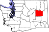
| Grant County | 025 | Ephrata | 1909 | Douglas County | Ulysses S. Grant (1822-1885), 18e president van de V.S. | 7004891200000000000♠89,120 | 7003268100000000000♠2,681 sq mi |
|
| Grays Harbor County | 027 | Montesano | 1854 | Thurston County | Grays Harbor, een waterlichaam genoemd naar ontdekkingsreiziger en koopman Robert Gray (1755-1806) | 7004727970000000000♠72,797 | 7003191700000000000♠1,917 sq mi |
|
| Island County | 029 | Coupeville | 1853 | Thurston County | Whidbey en Camano Eilanden | 7004785060000000000♠78,506 | 700220900000000♠209 sq mi |
|
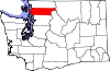
| JeffersonCounty | 031 | Port Townsend | 1852 | Thurston County | Thomas Jefferson (1743-1826), 3e president van de V.S. en belangrijkste auteur van de Onafhankelijkheidsverklaring | 7004298720000000000♠29,872 | 7003180900000000000♠1,809 sq mi |
|
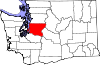
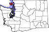
| King County | 033 | Seattle | 1852 | Thurston County | William R. King (1786-1853), vicepresident van de V.S. onder Franklin Pierce; in 1986 officieel hernoemd naar Martin Luther King, Jr. (1929–1968) | 7006193124900000000♠1,931,249 | 7003212600000000000♠2,126 sq mi |
|
| Kitsap County | 035 | Port Orchard | 1857 | King en Jefferson Counties | Opperhoofd Kitsap (ged. 1860), leider van de Suquamish stam | 7005251133000000000♠251,133 | 7002396000000000000♠396 vierkante mijl |
|
| KittitasCounty | 037 | Ellensburg | 1883 | Yakima County | Woord van de Kittitas-stam van onzekere betekenis, met populaire vertalingen variërend van "wit krijt" tot "land van overvloed". | 7004409150000000000♠40,915 | 7003229700000000000♠2,297 sq mi |
|
| Klickitat County | 039 | Goldendale | 1859 | Walla Walla County | Klickitat stam | 7004203180000000000♠20,318 | 7003187200000000000♠1,872 sq mi |
|
| LewisCounty | 041 | Chehalis | 1845 | Oorspronkelijk graafschap | Meriwether Lewis (1774-1809), de co-kapitein van de Lewis en Clark Expeditie | 7004754550000000000♠75,455 | 7003240800000000000♠2,408 sq mi |
|
| Lincoln County | 043 | Davenport | 1883 | Whitman County | Abraham Lincoln (1809-1865), 16e president van de V.S. | 7004105700000000000♠10,570 | 7003231100000000000♠2,311 sq mi |
|
| Mason County | 045 | Shelton | 1854 | King County | Charles H. Mason (1830-1859), eerste secretaris van het Washington Territory | 7004606990000000000♠60,699 | 70029610000000000♠961 sq mi |
|
| Okanogan County | 047 | Okanogan | 1888 | Stevens County | Een Salish indiaans woord dat "rendez-vous" betekent. | 7004411200000000000♠41,120 | 7003526800000000000♠5,268 sq mi |
|
| Pacific County | 049 | South Bend | 1851 | Lewis County | De Stille Oceaan | 7004209200000000000♠20,920 | 700297500000000♠975 sq mi |
|
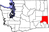
| Pend OreilleCounty | 051 | Newport | 1911 | Stevens County | De Pend d'Oreille Indiaanse stam | 7004130010000000000♠13,001 | 7003140000000000000♠1,400 sq mi |
|
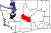
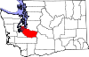
| Pierce County | 053 | Tacoma | 1852 | Thurston County | Franklin Pierce (1804-1869), 14e president van de V.S. | 7005795225000000000♠795,225 | 7003167600000000000♠1,676 sq mi |
|
| SanJuan County | 055 | Friday Harbor | 1873 | Whatcom County | San Juan Eiland | 7004157690000000000♠15,769 | 700217500000000♠175 vierkante mijl |
|
| Skagit County | 057 | Mount Vernon | 1883 | Whatcom County | De Skagit Indiaanse stam | 7005116901000000000♠116,901 | 7003173500000000000♠1,735 sq mi |
|
| Skamania County | 059 | Stevenson | 1854 | Clark County | Een Chinookan woord dat "snel water" betekent | 7004110660000000000♠11,066 | 7003165600000000000♠1,656 sq mi |
|
| Snohomish County | 061 | Everett | 1861 | Island County | De Snohomish stam | 7005713335000000000♠713,335 | 700320900000000♠2,090 sq mi |
|
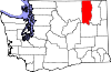
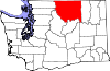
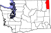
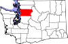
| Spokane County | 063 | Spokane | 1879 | Stevens County | De Spokane Indiaanse stam | 7005471221000000000♠471,221 | 7003176400000000000♠1,764 sq mi |
|
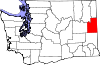
| 065 | Colville | 1863 | Walla Walla County | Isaac Stevens (1818-1862), 1e gouverneur van het Washington Territory | 7004435310000000000♠43,531 | 7003247800000000000♠2,478 sq mi |
| |
| Thurston County | 067 | 1852 | Lewis County | Samuel Thurston (1815-1851), de eerste afgevaardigde van het Oregon Territory in het Congres van de V.S. | 7005252264000000000♠252,264 | 700272700000000♠727 sq mi |
| |
| Wahkiakum County | 069 | Cathlamet | 1854 | Cowlitz County | Leider van de Wahkiakum ("Tall Timber"), inheemse Amerikaanse stam | 7003397800000000000♠3,978 | 700226400000000♠264 sq mi |
|
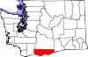
| Walla Walla County | 071 | Walla Walla | 1854 | Skamania County | De Walla Walla indianenstam, en ook een andere naam voor stromend water | 7004587810000000000♠58,781 | 700312700000000♠1,270 sq mi |
|
| Whatcom County | 073 | Bellingham | 1854 | Island County | Nooksack woord dat "luidruchtig water" betekent | 7005201140000000000♠201,140 | 7003212000000000000♠2,120 sq mi |
|
| Whitman County | 075 | Colfax | 1871 | Stevens County | Marcus Whitman (1802-1847), een presbyteriaanse missionaris | 7004447760000000000♠44,776 | 7003215900000000000♠2,159 sq mi |
|
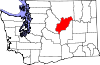
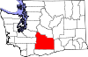
| Yakima County | 077 | Yakima | 1865 | Ferguson County (ter ziele) | De Yakama inheemse Amerikaanse stam | 7005243231000000000♠243,231 | 7003429600000000000♠4,296 sq mi |
|

Vroegere provincie namen
- Sawamish County, oorspronkelijk genoemd naar de inheemse stam Sahewamish, werd in 1864 omgedoopt tot Mason County.
- Slaughter County, oorspronkelijk genoemd naar luitenant William A. Slaughter die tijdens de Indianenoorlogen sneuvelde, werd in 1857 omgedoopt tot Kitsap County.
Voormalige provincies
- Ferguson County, genoemd naar de wetgever van Washington James L. Ferguson, werd op 23 januari 1863 gevormd uit Walla Walla County en eindigde op 18 januari 1865. Yakima County werd in zijn plaats gevormd.
Gerelateerde artikelen
Auteur
AlegsaOnline.com Lijst van districten in Washington Leandro Alegsa
URL: https://nl.alegsaonline.com/art/124638
Bronnen
- wsulibs.wsu.edu : "Historical Timeline of Events Leading to the formation of Washington State"
- historylink.org : "Washington Counties"
- epa.gov : "EPA County FIPS Code Listing"
- naco.org : "NACo - Find A County"
- historylink.org : "Washington Territorial Legislature creates Sawamish (Mason) County on April 15, 1854"
- historylink.org : "Slaughter County is renamed Kitsap County on July 13, 1857"
- historylink.org : "Ferguson County is established on January 23, 1863"
- historylink.org : "Milestones for Washington State History -- Part 2: 1851 to 1900"